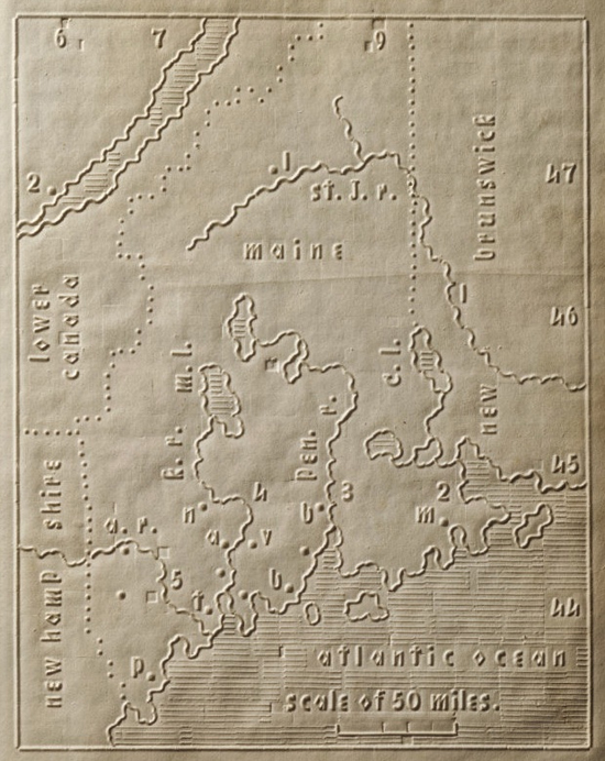
Maine, shown bordering Lower Canada, New Brunswick and New Hampshire.
“The tactile map shown here is taken from the Atlas of the United States Printed for the Use of the Blind, published in 1837. This precious, curious edition had a minuscule print run: no more than 50 copies were produced, for the New England Institute for the Education of the Blind. Only five copies now survive. The Atlas consists of 24 state maps, each accompanied by a text describing the state and explaining the symbols used. That text is not in Braille, but in a raised version of the Latin alphabet, which makes it easily decipherable for non-blind readers. In the introduction, Mr Howe writes:
“It is known that the contrivances hitherto used in Europe for the instruction of the blind in geography are very expensive, rude & imperfect, hardly deserving the name of maps. They were made by hand, either by puncturing through a common map the boundaries &c. or by first posting a map upon a board & then glueing upon it, strings or bits of pasteboard, to represent boundaries, rivers, &c.”
“There was no lettering, & no printed explanations, so that the blind could not tell by themselves, whether the portion they placed the finger upon was to represent one part of the globe or another; they required to be taught upon each map, by a seeing person.”
“This first attempt at embossing maps, was made at this institution [i.e. the aforementioned Institute]. After many expensive experiments a method of printing them was devised; & an atlas, the first of the kind, was published. It has been found a source of great pleasure & useful knowledge to the blind, who can study it unassisted by a seeing person.”
“[It] will give the blind the means of knowing the general outline, shape, & boundaries of each state; the rivers, principal towns, population & general statistics of the whole.”
Lines in the Darkness: An Atlas for the Blind, via Strange Maps.

